Map, inspect, and intervene on your field equipment — the application for technical services and operators.

All your field equipment, finally centralized

Urban furniture, roadways, lighting, signage, green spaces... A unique application for mapping, inspecting, and tracing all field interventions.


Without the right tool, it's hell

Excel spreadsheets, paper files, lost photos, unrecorded interventions: your equipment remains invisible and agents waste time.

Scattered data

Excel, paper, photos on personal smartphones: no one knows where to look anymore.

Time-consuming entry

Retyping on the computer in the evening what was noted by hand on site: systematic double entry.

No traceability

Who intervened on this candelabra last year? Impossible to find out.

No piloting

How many interventions this month? What costs? No consolidated reporting.

The solution KARTES Intervention

A mobile + web application that centralizes all your equipment (urban furniture, materials, installations...) and gives your field agents superpowers.

Mobile-first, designed for the field

Ultra-simple interface, usable even by non-technical agents. Works offline, synchronizes as soon as network connection is restored.

Photo + AI = capture in 10 seconds

Take a photo of the sign / streetlight / bench → the AI recognizes the type, reads the references, and auto-fills the form.

All your data on a single map

Geographic visualization of all your equipment, filterable by type, status, age, team.

Integrated Inspections and Interventions

Each item has its history: who did what, when, with before/after photos and signature.

All your assets, in one single tool

KARTES Intervention covers the main categories of public and private infrastructure.

Street furniture

Benches, trash cans, bus shelters, restrooms, fountains, children's play areas…

Public Lighting

Streetlights, chandeliers, electrical cabinets, event pedestals.

Roads & signage

Signs, markings, speed bumps, pedestrian crossings, guardrails, traffic lights.

Water & Sanitation

Fire hydrants, viewpoints, gutters, water points, hydraulic structures.

Green spaces

Trees, shrubs, hedges, flower beds, flower meadows, landscape furniture.

Cleanliness & Waste

Containers, glass bins, drop-off points, specific collections.

Parking & Mobility

Accessible parking spaces, EV charging stations, bike stations, parking areas, time recorders.

Incivilities & Vandalism

Graffiti, littering, illegal postings, citizen reports.

The Vision AI that changes everything

An agent processes 30 records in 5 minutes instead of 1 record in 5 minutes.

1 photo

The agent takes a photo of the item from the application.

AI analyzes

Type recognition, reference reading, detection of condition (graffiti, degradation, missing).

Pre-filled form

The agent validates or completes. The form is automatically filled out, faster than by hand.

Start in 3 steps

No heavy installation, no endless training. Your teams are up and running in just a few days.

01

Creation of your space

Free registration in 2 minutes. Choose the types of elements to track from our catalog of 200+ models.

02

Field Inventory

Your agents geolocate and photograph. AI pre-fills. Within a few days, all of your equipment is mapped.

03

Piloting & Interventions

Scheduled inspections, tracked interventions, automatic reporting for elected officials and services.

A transparent tariff grid


A transparent tariff grid


A transparent tariff grid


A transparent tariff grid


A transparent tariff grid


A transparent tariff grid


A transparent tariff grid


A transparent tariff grid


A transparent tariff grid


A transparent tariff grid


A transparent tariff grid


A transparent tariff grid /no_th

Start for free. Grow according to your needs. No commitment, cancellable at any time.

Discovered

0 €
Free, no commitment
Ideal for testing the tool or very small teams.
  • 3 users
  • 500 items
  • 30 interventions/month
  • 20 AI analyses/month
  • Offline mode
  • Community Support
Start for free

Starter

69 €
/ month HT
For small teams who want to professionalize their tracking.
  • 10 users
  • 5,000 items
  • Unlimited interventions
  • 500 AI analyses/month
  • Reporting & exports
  • Support email 48h
Choose Starter

Business

579 €
/ month HT
For large communities and organizations with high volumes.
  • 80 users
  • 200,000 elements
  • Unlimited AI Analyses
  • Team Geolocation
  • Custom Reporting
  • Priority support 24h
Choose Business

Enterprise — on quotation

Unlimited volumes, single sign-on (SSO), dedicated hosting, business IT system integration, on-site training, contractual SLA, project support.

Request a quote

All plans include: iOS / Android / Web application, offline mode, European hosting (GDPR), continuous updates.

Download the application

Registration and subscription are done directly through the mobile application.

Available on Google Play Coming soon on the App Store Coming soon

Measurable benefits

What our users gain every day.

×10

Field data entry speed

With AI Vision, a record is created in 10 seconds instead of 2-3 minutes.

100%

Traceability of interventions

Each action is timestamped, assigned to an agent, photographed. No more lost history.

0

Double entry hours

The data is created once on site, immediately available to everyone.

Questions FAQ

Everything you need to know before getting started with KARTES Intervention.

How much does a technical services intervention management application cost?

KARTES Intervention offers four formulas: Free Discovery (3 users), Starter at 69 €/month, Pro at 229 €/month, and Business at 579 €/month HT. An Enterprise plan on quote is available for large communities. No commitment, cancellable at any time.

Is it KARTES Is the intervention free?

Yes, the Discovery plan is free for life, without a credit card. It includes 3 users, 500 mapped items, 30 interventions per month, and 20 AI analyses. Ideal for testing the application before upgrading to a paid plan if your needs increase.

How does it work KARTES Offline intervention?

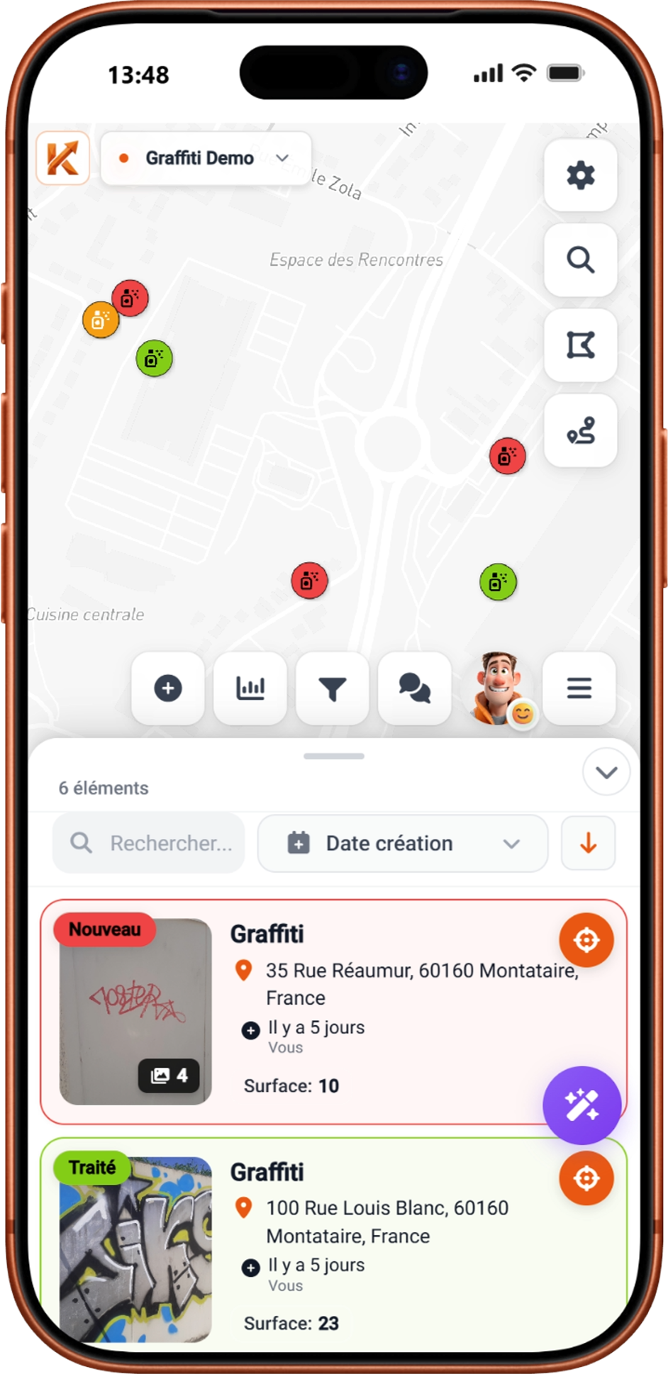
The application is designed with an offline-first approach: creating records, taking photos, filling out forms, and capturing signatures work without a network connection. As soon as a connection is detected, synchronization occurs automatically in the background. Your agents can work everywhere, even in dead zones or underground areas.

Where are the data stored KARTES Intervention?

All data is hosted in France (Paris region) with AWS, in compliance with the GDPR. Communications are encrypted with TLS, passwords hashed with bcrypt, and each workspace is strictly isolated. No data transfer outside the European Union.

Should the agents be trained to use KARTES Intervention?

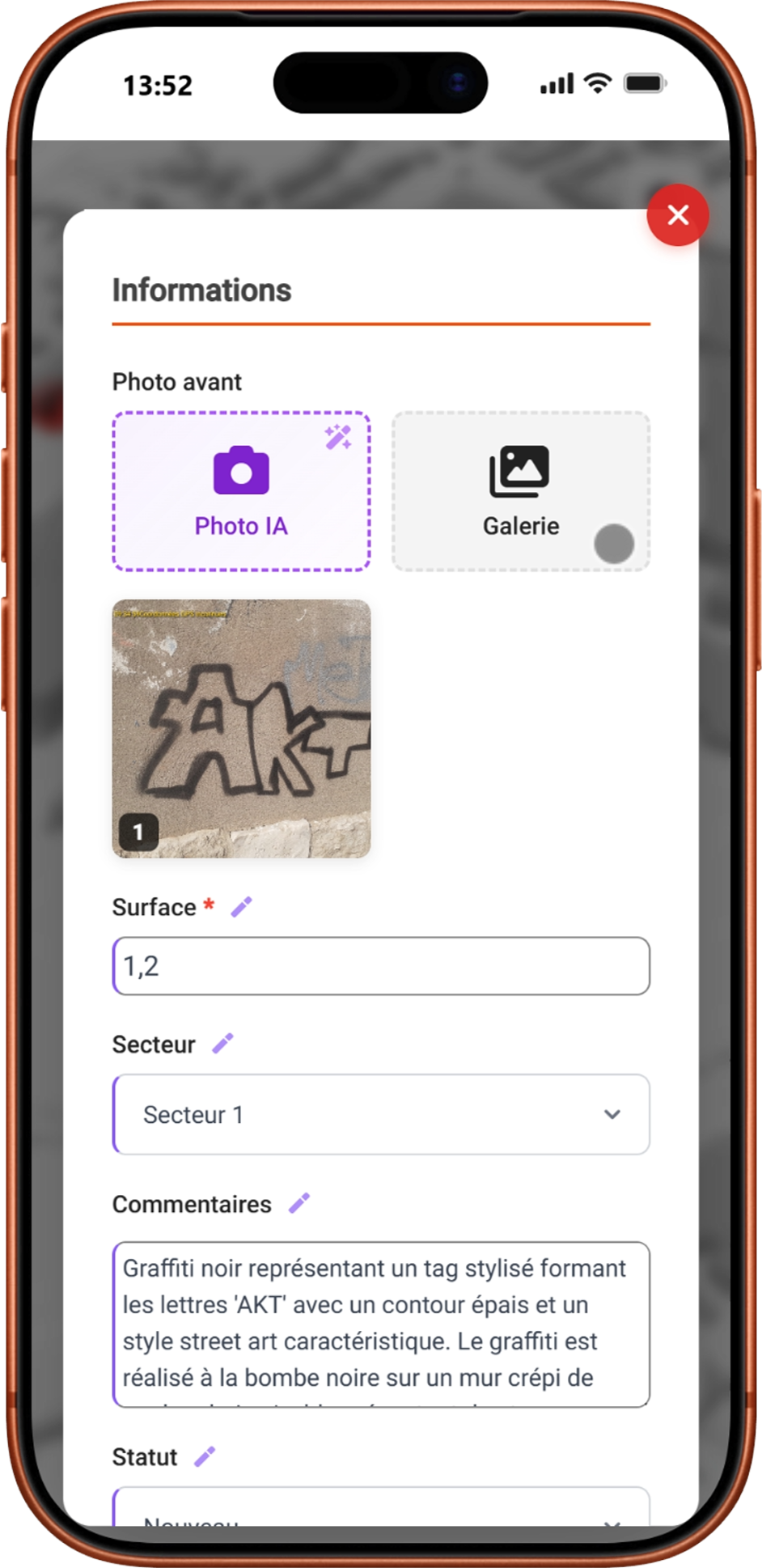
No, the interface is intentionally minimalist and free of technical jargon. Data entry is done through photos and drop-down menus, making it accessible to non-technical staff. Getting started takes just a few minutes, no dedicated training is required. An online guide is available if needed.

Can the input forms be customized in KARTES Intervention?

Yes, each type of element (streetlight, sign, bench, tree…) has its own editable form. You can add fields, set default values, create dropdown lists, and choose which information appears in the list view.

How to cancel my subscription KARTES Intervention?

Cancellation is done with a single click from your personal space, without notice or fees. Your data remains accessible until the end of the current period, then exportable in CSV, Excel, or GeoJSON format. No data loss.

How to try KARTES Intervention before subscribing?

Two options: start for free with the Discovery plan (no credit card required), or request a personalized demo. Our team presents the tool with support tailored to your business context and answers all your technical questions.

KARTES Intervention

Ready to simplify your asset management?

Start for free in 2 minutes or request a personalized demo.
Our team supports you in defining your needs and deploying quickly.